![](/images/other/stat-length.png)
![Excursión Senderismo Les Avirons - La Réunion - Observatoire des Papangues - Photo](https://media.geolcdn.com/t/1900/400/ext.pjpeg?maxdim=2&url=https%3A%2F%2Fservices.sitytrail.com%2FGeolivesWS%2FDownloadMedia.ashx%3FTrailID%3D447254%26Media%3De84d0fc0-7cd0-4b5e-a43f-300302b83197.jpg)
La Réunion - Observatoire des Papangues
olive2b
Usuario
![Longitud](/images/other/stat-length.png)
Longitud
608 m
![Altitud máxima](https://static1.geolcdn.com/siteimages/upload/files/1508320355ic_sort_altitude_max_24dp.png)
Altitud máxima
1328 m
![Desnivel positivo](https://static1.geolcdn.com/siteimages/upload/files/1508320355ic_sort_den_pos_24dp.png)
Desnivel positivo
24 m
![Km-Effort](/images/other/stat-length.png)
Km-Effort
898 m
![Altitud mínima](https://static1.geolcdn.com/siteimages/upload/files/1508320355ic_sort_altitude_min_24dp.png)
Altitud mínima
1294 m
![Desnivel negativo](https://static1.geolcdn.com/siteimages/upload/files/1508320355ic_sort_den_neg_24dp.png)
Desnivel negativo
15 m
![Boucle](https://static1.geolcdn.com/siteimages/upload/files/16400158638029165_repeat_loop_refresh_sync_direction_icon.png)
Boucle
Sí
Fecha de creación :
2016-03-09 00:00:00.0
Última modificación :
2016-03-09 00:00:00.0
![Senderismo](https://static1.geolcdn.com/sitytour/trail-icons/101.png)
17m
Dificultad : Muy fácil
![Escanee este código QR para abrir la excursión en la aplicación SityTrail](https://capi.geolives.com/qq0zvz2zws4bq2lad0pu/sitytour/trails/447254/qr.png?size=200)
Aplicación GPS de excursión GRATIS
A propósito
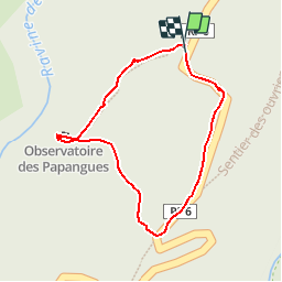
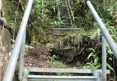
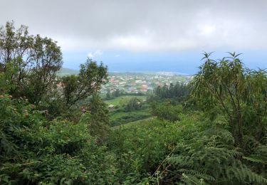
Ruta Senderismo de 608 m a descubrir en La Reunión, Desconocido, Les Avirons. Esta ruta ha sido propuesta por olive2b.
Descripción
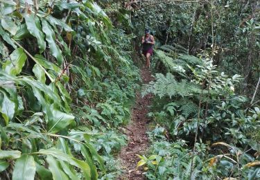
Aucun difficulté. Juste une boucle de 500 mètres pour observer les Papangues. Mais pour ça, il faut avoir de la chance.
Localización
País:
France
Región :
La Reunión
Departamento/provincia :
Desconocido
Municipio :
Les Avirons
Localidad:
Unknown
Salida:(Dec)
Salida:(UTM)
329918 ; 7655949 (40K) S.
Comentarios
Excursiones cerca
![Excursión Senderismo Saint-Louis - Sentier découverte des Makes - Photo](https://media.geolcdn.com/t/375/260/e0a2a7b6-7fb4-493b-b407-5bd5656a61ed.jpg&format=jpg&maxdim=2)
![Senderismo Senderismo](https://static1.geolcdn.com/sitytour/trail-icons/101.png)
Sentier découverte des Makes
Senderismo
Fácil
Saint-Louis,
La Reunión,
Desconocido,
France
![](/images/other/stat-length.png)
5,7 km | 10 km-effort
2h 41min
![](https://static1.geolcdn.com/siteimages/upload/files/16400158638029165_repeat_loop_refresh_sync_direction_icon.png)
Sí
![Excursión Senderismo Les Avirons - La Réunion - Boucle au Tevelave par le Sentier Grande Terre - Photo](https://media.geolcdn.com/t/375/260/ext.jpg?maxdim=2&url=https%3A%2F%2Fservices.sitytrail.com%2FGeolivesWS%2FDownloadMedia.ashx%3FTrailID%3D447253%26Media%3Dfix__20150719113959.jpg)
![Senderismo Senderismo](https://static1.geolcdn.com/sitytour/trail-icons/101.png)
La Réunion - Boucle au Tevelave par le Sentier Grande Terre
Senderismo
Fácil
Les Avirons,
La Reunión,
Desconocido,
France
![](/images/other/stat-length.png)
11,2 km | 16,9 km-effort
4h 1min
![](https://static1.geolcdn.com/siteimages/upload/files/16400158638029165_repeat_loop_refresh_sync_direction_icon.png)
Sí
![Excursión Senderismo Les Avirons - Sur la route forestière de Tévelave - Photo](https://media.geolcdn.com/t/375/260/109dccb4-07aa-4f7e-9cbd-0938a0d048ec.jpg&format=jpg&maxdim=2)
![Senderismo Senderismo](https://static1.geolcdn.com/sitytour/trail-icons/101.png)
Sur la route forestière de Tévelave
Senderismo
Difícil
Les Avirons,
La Reunión,
Desconocido,
France
![](/images/other/stat-length.png)
25 km | 36 km-effort
4h 37min
![](https://static1.geolcdn.com/siteimages/upload/files/16400158638029165_repeat_loop_refresh_sync_direction_icon.png)
Sí
![Excursión Senderismo Saint-Louis - 11840720-makes/petit mapou par 11e ligne - Photo](https://media.geolcdn.com/t/375/260/ec2689fe-b6ab-4eb5-a4db-eec5e368e542.jpg&format=jpg&maxdim=2)
![Senderismo Senderismo](https://static1.geolcdn.com/sitytour/trail-icons/101.png)
11840720-makes/petit mapou par 11e ligne
Senderismo
Muy difícil
Saint-Louis,
La Reunión,
Desconocido,
France
![](/images/other/stat-length.png)
15,5 km | 29 km-effort
5h 51min
![](https://static1.geolcdn.com/siteimages/upload/files/16400158638029165_repeat_loop_refresh_sync_direction_icon.png)
Sí
![Excursión Senderismo Les Avirons - sentier des ouvriers - Photo](https://media.geolcdn.com/t/375/260/c581b641-d6b2-425a-875b-a73ca70de4af.jpg&format=jpg&maxdim=2)
![Senderismo Senderismo](https://static1.geolcdn.com/sitytour/trail-icons/101.png)
sentier des ouvriers
Senderismo
Difícil
Les Avirons,
La Reunión,
Desconocido,
France
![](/images/other/stat-length.png)
9,5 km | 16,8 km-effort
3h 8min
![](https://static1.geolcdn.com/siteimages/upload/files/16400158638029165_repeat_loop_refresh_sync_direction_icon.png)
Sí
![Excursión Senderismo Les Avirons - Sentier des ouvriers 20190224 - Photo](https://media.geolcdn.com/t/375/260/869a0788-b6f9-4f1f-8850-e496527cea81.jpg&format=jpg&maxdim=2)
![Senderismo Senderismo](https://static1.geolcdn.com/sitytour/trail-icons/101.png)
Sentier des ouvriers 20190224
Senderismo
Fácil
Les Avirons,
La Reunión,
Desconocido,
France
![](/images/other/stat-length.png)
2,9 km | 4,3 km-effort
1h 29min
![](https://static1.geolcdn.com/siteimages/upload/files/16400158638029165_repeat_loop_refresh_sync_direction_icon.png)
Sí
![Excursión Senderismo Saint-Louis - La boucle des Makes - Photo](https://media.geolcdn.com/t/375/260/ext.jpg?maxdim=2&url=https%3A%2F%2Fstatic1.geolcdn.com%2Fsiteimages%2Fupload%2Ffiles%2F1553511878bg_sport_marche.png)
![Senderismo Senderismo](https://static1.geolcdn.com/sitytour/trail-icons/101.png)
La boucle des Makes
Senderismo
Difícil
Saint-Louis,
La Reunión,
Desconocido,
France
![](/images/other/stat-length.png)
21 km | 39 km-effort
7h 58min
![](https://static1.geolcdn.com/siteimages/upload/files/16400158638029165_repeat_loop_refresh_sync_direction_icon.png)
Sí
![Excursión Senderismo Les Avirons - Sentier des tamarins, vue sur les Makes - Photo](https://media.geolcdn.com/t/375/260/ext.jpg?maxdim=2&url=https%3A%2F%2Fstatic1.geolcdn.com%2Fsiteimages%2Fupload%2Ffiles%2F1553511878bg_sport_marche.png)
![Senderismo Senderismo](https://static1.geolcdn.com/sitytour/trail-icons/101.png)
Sentier des tamarins, vue sur les Makes
Senderismo
Fácil
Les Avirons,
La Reunión,
Desconocido,
France
![](/images/other/stat-length.png)
4,6 km | 7,7 km-effort
1h 38min
![](https://static1.geolcdn.com/siteimages/upload/files/16400158638029165_repeat_loop_refresh_sync_direction_icon.png)
Sí
![Excursión Senderismo L'Étang-Salé - Le piton de la croix - Photo](https://media.geolcdn.com/t/375/260/ext.jpg?maxdim=2&url=https%3A%2F%2Fstatic1.geolcdn.com%2Fsiteimages%2Fupload%2Ffiles%2F1553511878bg_sport_marche.png)
![Senderismo Senderismo](https://static1.geolcdn.com/sitytour/trail-icons/101.png)
Le piton de la croix
Senderismo
Fácil
L'Étang-Salé,
La Reunión,
Desconocido,
France
![](/images/other/stat-length.png)
3,6 km | 6,9 km-effort
1h 30min
![](https://static1.geolcdn.com/siteimages/upload/files/16400158638029165_repeat_loop_refresh_sync_direction_icon.png)
Sí